Introducing our Plains Indian Map project

December 27, 2016
Plains Indian Map Project
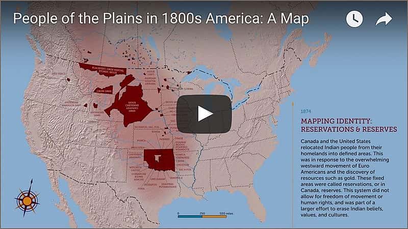
This past fall, the Buffalo Bill Center of the West, with the help of generous funding from The Brown Foundation, Inc., of Houston, added an interactive Plains Indian map in our Plains Indian Museum. A fusion of scholarship and educational interpretation, the map shows more than 45 different Indian cultures, their distribution across the Plains, and their movements through 230 years. Territorial, treaty, reservation, and state boundaries flow in an animated timeline.
The map online
Now, we are excited to announce the Plains Indian Map’s launch online. Take a look at this innovative project through the video below.
The map is recommended for a broad audience, including K–12 teachers and students. Viewers can pause the online animation at any point to study a particular map.
Written By
Nancy McClure
Nancy now does Grants & Foundations Relations for the Center of the West's Development Department, but was formerly the Content Producer for the Center's Public Relations Department, where her work included writing and updating website content, publicizing events, copy editing, working with images, and producing the e-newsletter Western Wire. Her current job is seeking and applying for funding from government grants and private foundations. In her spare time, Nancy enjoys photography, reading, flower gardening, and playing the flute.
You May Also Like
A Masterpiece Finds a New Home at the Center: Bierstadt’s ‘Wind River Country, Wyoming’
Feb 03, 2025
The Buffalo Bill Center of the West in Cody, Wyoming,...
How the Rocky Mountains Formed: A Journey Through Changing Scientific Ideas
Dec 11, 2025
"Science is finding out where we're wrong." -J. Robert Oppenheimer...
A Spirited Wild West Volley – Points West Online
Jul 10, 2024
Originally published in Points West magazine History EditionWinter 2022 A...
Why These Objects? A Closer Look at the Buffalo Nation Spotlights
Jan 29, 2026
As the opening of the Buffalo Nation spotlights approaches, a...
Research Made Easy: Exploring the McCracken Research Library’s Collections
Mar 23, 2026
Archival and library research can feel overwhelming for even the...
Armed in the Colonies: Firearms, Militia, and Early American Law
Mar 16, 2026
American society has always been connected to firearms culture in...
A Fleeting Season: Indian Summer in History and Art
Sep 09, 2025
First Use of "Indian Summer" In 1778 in his collection...
St. Labre Students Make Their Fall Visit to the Center
Nov 20, 2025
Raptor Husbandry Specialist Brandon Lewis and volunteer Jeanne Meronek assist...
Earn Your Spurs – Points West Online
Jul 22, 2024
Originally published in Points West magazine Spring 2023 The Way...
Buffalo Bill Center of the West Mourns the Death of Photographer and Storyteller Ken Blackbird
Jan 07, 2026
He had a talent for narration, showering his audience with...